Find out where to hit the trail in this Sonoran Desert city
A hike up one of the Valley of the Sun’s iconic trails to experience an Arizona sunset (and to capture photos, of course) is a rite of passage for locals as well as visitors to the Sonoran Desert. Nature seekers will find a wide variety of hiking trails and scenic summits in Tempe, Phoenix and beyond.
Important considerations before you hit the trail include trailhead location, parking, distance/duration, elevation and difficulty level — to name a few. That said, we hope our guide helps you plan the perfect hike for you.
Know before you go: Hiking in Tempe is a great way to experience our destination, but please do so safely! If you plan to hike a trail, please check the weather prior and plan accordingly. Bring plenty of water and don’t bring your dog with you if it’s over 100 degrees Fahrenheit. For more hiking tips, visit Arizona State Parks and Trails’ hiking safety page.
1. Papago Park
625 N. Galvin Parkway, Phoenix, AZ 85008
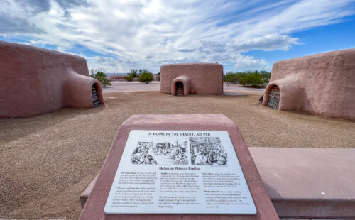
Papago Park offers several easy hikes, and it’s easy to get to from any part of the Valley. The trailhead, just west of the parking lot at College and Curry, is an easy hike that provides views of Downtown Tempe and Tempe Town Lake from the summits. This trail is also home to Loma del Rio, a Hohokam ruin. To get to the ruin, continue along the path towards the freeway and then veer right. Once you pass the summit of the next hill, you’ll see it next to a ramada.
There’s another popular trailhead on the west side of Papago Park. You can access the Double Butte Loop, a great trail for mountain bikers and hikers, leading north towards the picturesque red buttes. You can access it by turning west into the parking lot just across Galvin Parkway from the entrance to The Phoenix Zoo, located just north of Van Buren Street.
The most well-traveled path in Papago Park is Hole-in-the-Rock Trail, which leads to a very appropriately named feature. You can get to this trail by entering The Phoenix Zoo parking lot. Turn left once you enter the zoo and continue until you see an additional parking lot near the butte, next to the lagoon. Hole-in-the-Rock Trail is a quick hike, 5 to 10 minutes. This spot is bustling when the sun is setting, but the view from the top is just lovely.
Papago Park is great for hiking, biking and bringing your dog. View an overview of the park with more information on all the trails.
- Double Butte Loop distance: 2.3 miles | Elevation gain: 50 feet | Difficulty Rating: easy
- Hole-in-the-Rock Trail distance: 0.2 miles | Elevation gain: 200 feet | Difficulty rating: easy
2. South Mountain Park and Preserve
Pima Canyon Trailhead: 4800 E. Pima Canyon Road, Phoenix, AZ 85042 (near Tempe)
Beverly Canyon Trailhead: 8800 S. 46th St., Phoenix, AZ 85044 (near Tempe)
Main entrance: 10211 S. Central Ave., Phoenix, AZ 85042
At 16,000-acres, South Mountain Park and Preserve is one of the country’s largest municipal parks. With more than 58 miles of trails for hiking, biking and horseback riding, the recreation possibilities seem limitless. If you’re reaching the park from Tempe, we have some recommendations for you.
A favorite trek is the Marcos De Niza Trail via Pima Canyon Trailhead. Just a few miles southwest of Tempe, this 1.7-mile loop offers fantastic views of the Valley’s famous Sonoran Desert landscape, including the wildflowers each spring. This trail is a great workout and perfect for a quick getaway from the city. Other trails accessible via the Pima Canyon Trailhead include Desert Classic Trail, Pima East Loop Trail, Pima Wash Trail and Pima West Loop Trail. Also conveniently located near Tempe, Beverly Canyon Trailhead leads to Beverly Canyon Trail, Javelina Canyon Trail, Javelina Connector Trail and Ridgeline Trail
For those seeking a scenic vantage point, but prefer to skip the hike, Dobbins Lookout is situated at the park’s highest publicly accessible point (2,330 feet) and is accessible by vehicle. Use the park’s the main entrance gate for easiest access (approx. 20-minute drive) and plan ahead because parking at the top is limited. Once you’ve secured parking, you’re set to enjoy the view of the city skyline and mountains beyond.
South Mountain trails vary from quick trips to longer hikes. Some trails are relatively flat, and others are steeper. Check the City of Phoenix website for more detailed information about South Mountain trails.
- Beverly Canyon Trail Loop distance: 2.2 miles | Elevation gain: 275 feet | Difficulty rating: moderate
- Marcos de Niza Trail Loop distance: 1.7 miles | Elevation gain: 331 feet | Difficulty rating: moderate
3. “A” Mountain aka Hayden Butte
Hayden Butte Trailhead: E. Rio Salado Pkwy & S. Mill Ave
Leonard Monti Trailhead: Just east of the Tempe Transportation Center (200 E. 5th St., Tempe, AZ 85281)
Perhaps one of the most convenient hikes is “A” Mountain, located in the heart of Downtown Tempe. Easily recognizable by the 60-foot A that adorned the side of the butte since 1938, hiking this landmark is a must for unique views of Tempe Town Lake, Mountain America Stadiums and other local landmarks.
The Leonard Monti Trail begins behind the Tempe Transportation Center, and the Hayden Butte Trailhead is located behind Tempe Mission Palms Hotel. The two converge on a wide, paved path that goes on to include a series of wooden steps and the peak is in its natural, craggy state. This short hike is high-intensity with steep elevation gain. However, there are various points to stop, rest as needed and take photos along the way. Like most trails in the area, this is a preserve, so look for the trailhead signs and stay on the marked paths.
Like most trails in the area, this is a preserve, so look for the trailhead signs and stay on the marked paths. Be sure to keep your eyes peeled for the petroglyphs left by some of Tempe’s first inhabitants (read more on the site’s history). The last part of the hike is steep, but the view from the top is an excellent reward for your effort. And, when you’re finished, the restaurants along Mill Avenue are waiting to refuel you.
Although this is not a trail for biking, leashed dogs are welcome.
- Hayden Butte Trail distance: 0.7 miles | Elevation gain: 278 feet | Difficulty rating: moderate
- Leonard Monti Trail distance: 1.2 miles | Elevation gain: 344 feet | Difficulty rating: moderate
4. Piestewa Peak
302 Trailhead: 2701 E. Piestewa Peak Drive, Phoenix, AZ 85016
304 Trailhead: 7200 N. Piestewa Peak Drive, Phoenix, AZ 85016
Another excellent spot for a hike is Piestewa Peak. It is a great leg workout for sure, but the views of the Valley from the top are amazing. Phoenix Mountains Park and Recreation Area and Dreamy Draw Recreation Area surround the base of this mountain, so there are numerous trailheads in this area, including easier options. Visit their website for updates on their Trailhead Improvement Project to see the best entrance to your trail of choice. This trail continues for quite a way, but of course, you can choose the best stopping point for you. Be on the lookout for the sparkling white boulders along the path.
As one of the more challenging hikes, Piestewa Peak is relatively steep and a great workout with views of Phoenix. View this map to see what others said about the trail and to learn more about Piestewa Peak.
- Piestewa Peak Summit Trail distance: 1.2 miles | Elevation gain: 1,200 feet | Difficulty rating: extremely difficult
- Piestewa Peak Nature Trail distance: 1.4 miles | Elevation gain: 180 feet | Difficulty rating: moderate
5. Camelback Mountain
Echo Canyon Trailhead: 4925 E. McDonald Drive, Phoenix, AZ 85018
Cholla Trailhead: 5150 N. Invergordon Road, Paradise Valley, AZ 85253
This iconic landmark in Phoenix is said to look like a camel’s back (hence the name). There are two trailheads leading to the summit, perched at 1,420 feet, both of which are rated extremely difficult. Echo Canyon Trail is a steep, very rocky, out-and-back trail that requires the assistance of handrails and other aides to reach the summit. Cholla Trail is a slightly longer alternative that is also steep and rocky at times, as it traverses the eastern slope or “hump” of camel’s silhouette. The Cholla Trailhead has recently been upgraded with a new trailhead and amenities, including a drinking fountain, restrooms and bike racks.
Camelback Mountain is not an easy climb, so come prepared with the right shoes and plenty of water, and you’ll be rewarded with 360-views of the Valley of the Sun. The trails are open from sunrise to sunset for hikers to enjoy beautiful views of the city. Dogs are not permitted on either trail, but you could see your fair share of desert critters. Be advised: During peak hours, including weekend mornings, parking can be hard to find.
- Echo Canyon Trail distance: 1.14 miles | Elevation gain: 1,400 feet | Difficulty rating: extremely difficult
- Cholla Trail distance: 1.5 miles | Elevation gain: 1,420 feet | Difficulty rating: extremely difficult
Hike Responsibly
The Tempe Tourism Office encourages visitors to out Sonoran Desert landscapes to embrace the Seven Principles of Leave No Trace, which are the minimum impact practices for anyone visiting the outdoors.
These principles can be applied anywhere — from remote wilderness areas to local parks — and are especially important for the preservation of spaces that visitors frequent in and around Tempe. Each principle covers a specific topic and provides detailed information for minimizing impacts:
- Plan ahead & prepare
- Travel & camp on durable surfaces
- Dispose of waste properly
- Leave what you find
- Minimize campfire impacts (where applicable)
- Respect wildlife
- Be considerate of others.

